
Vast and Beautiful
In Southeastern Oregon and into Idaho, high desert spreads for thousands of square miles. The Owyhee River runs through this desert, winding its way around and through steep rhyolite cliffs. Thousands of years of wind and water have carved surreal masterpieces of rock sculptures. The air is crisp, clean and clear. Starlight sprinkles over the desert and cliffs like an overpopulation of fireflies - you just can't look away. This is the BLM-managed Owyhee River Wilderness Area Canyonlands, not the Canyonlands of Utah. I think the Owyhee Canyonlands is just as beautiful as the Utah Canyonlands, but with a whole lot fewer people and an "out there" feel that is about as unique as you can get. I didn't even know this was in our state until my son discovered it while looking for places to go for solitude. Well, he hit a home run on this one.
From the website: Wildowyhee.org: The largest untouched stretch of the American West, Oregon's Owyhee Canyonlands is a place to recharge your soul. Red-rock canyons, cool rivers and star-filled skies. Explore it. Experience it. And fall in love. Carved by desert rivers winding toward the Pacific, the Owyhee Canyonlands are the largest undeveloped natural area left unprotected in the Lower 48. Just a handful of paved roads cross these 5 million acres of craggy, red-rock canyons, blue-ribbon trout streams and vast rolling hills that serve as prime habitat for golden eagles, bighorn sheep and the Greater sage-grouse, which is threatened with extinction.
There is a 66 page writeup with lots of pictures and maps here. Marguerite and I also made a trip to the same general area in 2016 and you can read about that trip here. I recommend that you at least peruse both of those writeups.
Getting there is not trivial and perhaps the reason there are so few people. A few popular areas like Succor Creek State Natural Area do not require all-wheel drive, but if you are going to places like The Honeycombs, Three Forks or Anderson Crossing, then you will likely want a high-clearance vehicle with all-wheel drive. When going here I take our four-wheel 1999 Chevy Silverado with good tires. Carry a good spare and if you are really going out there, carry some instant tire repair. If it rains, then the roads get bad fast. Find another place to go.
You can hike, bike, paddle and backpack here. But if you want to go to some of the more out-of-the-way places then you really need to do your homework.
Great Site: Visitor’s Guide to the Owyhee Canyonlands
Owyhee Canyonlands Adventures
Bucket List Trails
Campgrounds
Indigenous Peoples | Climate | Animals & Plants & Insects | Stinging Nettles | Chukar | California Quail | Greater Sage Grouse | Aging a Rattlesnake | Rhyolite
When I tell people I am going to “Owyhee,” they always ask, “Where? “Hawaii?” No, Owyhee: When British and American traders visited the Hawaiian Islands in the early 19th century, they used the term “Owyhee,” to reference the people who lived there, according to Lalia Boone who wrote the book “Idaho Place Names: A Geographical Dictionary.” Some Owyhees sailed to the Northwest and began working for fur trade companies.
After trade posts were set up along the Pacific Coast, Donald Mackenzie, who worked for a Montreal based fur trade company, hired three Owyhees and several other trappers to explore the Snake River, hunt beaver and trade.
“The Owyhees were primarily hired for the purposes of carrying on a more successful trade with Bannock and Shoshoni Indians,” wrote Boone.
The group journeyed into what is now known as Owyhee County. Along the way, the three Owyhees left the group to further explore the more remote sections of the area’s river and mountains and were never found, according to the Idaho Historical Society.
Per Owyhee Canyonlands: Cultural Heritage The Owyhee Canyonlands is home to a living cultural richness for the indigenous Northern Paiute, Bannock and Shoshone tribes. These ancestral lands contain areas considered sacred and the landscapes, rivers, fish and wildlife support tribal traditions to this day.
For at least 13,0000 years semi-nomadic hunters and gathers have inhabited the Owyhee Canyonlands. They shared a lifestyle and culture similar to the indigenous tribes of the Great Plains, seeking out wheatgrass, fescue and Indian rice to winnow and grind into flour. More…
Please be respectful of our past and don’t disrupt archeological sites and for goodness sake, please DON’T DRAW OVER THE EXISTING PETROGLYPS AND DON’T ADD YOUR OWN! Take only pictures and leave only footsteps.
Per BestPlaces: Jordan Valley: Jordan Valley gets some kind of precipitation, on average, 77 days per year. Precipitation is rain, snow, sleet, or hail that falls to the ground. In order for precipitation to be counted you have to get at least .01 inches on the ground to measure.
Summer High: the July high is around 88 degrees
Winter Low: the January low is 19
Rain: averages 11 inches
of rain a year
Snow: averages 11 inches of snow a year
Per the Oregon Encyclopedia: Plant communities in the canyonlands have been influenced by the nearby Great Basin Desert. Salt-scrub ecosystems have arid-adapted shrub species, including greasewood, shadscale, saltbush, and spiny hopsage. In the uplands are sweeping sagebrush-bunchgrass prairies, with patches of western juniper and mountain mahogany. Cottonwoods and quaking aspen groves trace river margins and spring-fed green meadows. During springtime's fleeting sun-showers, balsamroot, paintbrush, lupine, phlox, penstemon, globemallow, and a plentitude of other wildflowers bloom.
Several plant species, such as Owyhee clover and Packard's blazingstar, are endemics—that is, they are found nowhere else on the planet. Native vegetation zones have been distorted by overgrazing and the long-term human suppression of natural fire cycles, which periodically cleared accumulated dead entanglements. Ecological degradation worsened with the accidental introduction of Asian cheatgrass in the 1800s, along with invasive Russian thistle (tumbleweed).
Animals typical of the American West's drylands inhabit the area, including pronghorn antelope, bighorn sheep, coyotes, badgers, kangaroo rats, antelope squirrels, black-throated sparrows, golden eagles, and prairie falcons. And though its numbers are dwindling, the secluded terrain offers habitat for the greater sage-grouse, which is being considered for federal protection.
Sun-drenched sandy-rocky habitats are conducive to reptiles, including horned lizards, leopard lizards, collared lizards, striped whipsnakes, and rattlesnakes. The Owyhee drainage is the only place in Oregon where the diminutive ground snake has been recorded. Although secretive and rarely seen, its bright red-orange and black dorsal pattern is eye-catching. This is also one of the few locations in the state where the Woodhouse's toad lives. After dark, along with bats and burrowing owls, prowling kit foxes and giant desert hairy scorpions can sometimes be glimpsed in the beam of a flashlight.
Some of the Plants and Animals I (or someone I love) have had personal contact with include:

Gary's Encounter with Stinging Nettle
Ouch! Yes, they sting
Per Healthline: Stinging nettle (Urtica dioica) has been a staple in herbal medicine since ancient times.
Ancient Egyptians used stinging nettle to treat arthritis and lower back pain, while Roman troops rubbed it on themselves to help stay warm.
Its scientific name, Urtica dioica, comes from the Latin word uro, which means “to burn,” because its leaves can cause a temporary burning sensation upon contact.
The leaves have hair-like structures that sting and also produce itching, redness and swelling (2Trusted Source).
However, once it is processed into a supplement, dried, freeze-dried or cooked, stinging nettle can be safely consumed. Studies link it to a number of potential health benefits.
There are at least six benefits of stinging nettles:
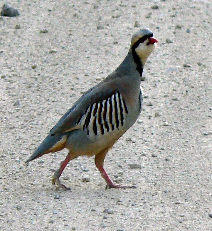
Smart Aleck Chuckar
Chukar are all over the cliffs, valleys and mountains of the Owyhee’s. I have not seen many, but I hear them all the time. During “that time of year” they get rather bold. We have happened upon them sauntering along the dirt roads in the Owyhee back country, basically daring us to try to pass them. They are hunted and I suspect they are pretty tasty, probably like a quail.
Per All About Birds: Introduced from Eurasia, the sandy-brown Chukar is a game bird that lives in high desert plains of western North America, as well as in Hawaii and New Zealand. Its namesake call echoes across dry rocky slopes. It runs and scampers up steep terrain with the agility and speed of a mountain goat, prompting hunters to nickname it the "devil bird" for the brutal chase it gives. Dark bars on the sides and a band across the head and neck adorn this red-billed game bird.
Per All About Birds: The California Quail is a handsome, round soccer ball of a bird with a rich gray breast, intricately scaled underparts, and a curious, forward-drooping head plume. Its stiffly accented Chi-ca-go call is a common sound of the chaparral and other brushy areas of California and the Northwest. Often seen scratching at the ground in large groups or dashing forward on blurred legs, California Quail are common but unobtrusive. They flush to cover if scared, so approach them gently.
We saw Greater Sage Grouse back in 2014 but weren’t able to get pictures. In 2021 Gary, Nick and I saw many Sage Grouse along Fenwick Road in Owyhee. Check out the video.
Per All About Birds: Each spring, at dawn, the sagebrush country of western North America fills with a strange burbling sound and an even stranger sight. Dozens of male Greater Sage-Grouse puff their chests and fan their starburst tails like avant-garde turkeys. They inflate bulbous yellow air sacs and thrust with their heads to produce weird pops and whistles. The rest of the year these birds melt away into the great sagebrush plains that are their only home. Habitat fragmentation and development have caused severe declines for this spectacular bird.

Greater Sage Grouse Along Fenwick Road
The tissue that makes up the rattle is rather like a thin brittle fingernail. Just as a human can tear a fingernail, when the rattle gets longer than about 8-10 segments, some may break off and be lost. If the string of rattle segments ends in a smooth rounded button, all the segments are there and the rattle is complete. If the rattle string ends in a squarish or tiered nubbin, the rattle has been broken and some segments have been lost.
These two factors, adding segments several times a year and losing segments through breakage, make it impossible to tell a Rattlesnake's age by simply counting its rattles.
According to the online version of the Encyclopedia Britannica: Rhyolite is an extrusive igneous rock that is the volcanic equivalent of granite. Extrusive rock is any rock derived from magma (molten silicate material) that was poured out or ejected at the Earth's surface. By contrast, intrusive rocks (granite, for example) are formed from magma that was forced into older rocks at depth within the Earth's crust; the molten material then slowly solidifies below the Earth’s surface, where it may later be exposed through erosion.
Rod's Report: Three Dudes and a Dog Discover Owyhee Canyonlands
Rod's Report: Steens Mountain and Owyhee Canyon
Owyhee Canyonlands: Getting there
BLM: Owyhee River Wilderness Area
BLM: North Fork Owyhee Wilderness Area (Idaho)
National Wild and Scenic River System: Owyhee River
Oregon Natural Desert Association: Leslie Gulch
ShareOregon: Owyhee Canyonlands
Outdoor Project: The Honeycombs
Wilderness Connect: Owyhee River Wilderness
Succor Creek State Natural Area
Less Traveled Northwest: Upper Owyhee Canyons Hikes.
Visit Idaho: Owyhee Uplands Backcountry Byway
BLM: The Owyhee Uplands Backcountry Byway Guide
BLM: Owyhee Uplands Back Country Byway
Search the internet for hikes in Owyhee area
Search the Owyhee Uplands Back Country Byway
The Owyhee Canyonlands - An Outdoor Adventure Guide
100 Hikes / Travel Guide: Eastern Oregon by William Sullivan
BLM: North Fork Campground (Idaho)
Hipcamp: North Fork Campground
Oregon Natural Desert Association
National Wild and Scenic River System