From the website Visit Arizona: Sedona: From the very first glimpse of the glorious Sedona red rock landscape, visitors feel the majesty and mystery of a place sacred to its earliest prehistoric settlers. It’s been said, “God created the Grand Canyon but He lives in Sedona.” It is awesome yet it invites personal exploration.
Above plains and canyons soar brilliantly hued cliffs and rugged spires of sandstone sculpted by eons of ocean tides and desert winds. It is a 25 square-mile enclave surrounded by vast stretches of national and state forestlands that make Sedona seem like a world apart.
Located two hours north of Phoenix, and 30 miles south of the Flagstaff peaks, Sedona’s mild four-season climate and high desert terrain assure good year-round weather for vacationers and outdoor enthusiasts. Oak Creek Canyon, a spectacular 16-mile gorge with streams and waterfalls between sheer rock walls, beckons hikers, campers and fishermen. It has been termed by Rand McNally as one of the eight most scenic drives in America.
Nearly four million travelers visited Sedona last year, rivaling the Grand Canyon, just 2 1/2 hours north, as a world class destination. Yet the influx does not disturb the small-town ambiance that is part of Sedona’s charm. Shopping plazas, gift boutiques, galleries and restaurants abound. Tlaquepaque–an Indian name meaning “the best of everything”–is modeled after a Mexican village, made up of quaint courtyards surrounded by specialty shops, galleries and restaurants. Read more...
March 28 to April 3, 2021: Marguerite and I stayed in Cottonwood, AZ rather than Sedona only because we didn't want to pay for the more expensive places to stay in Sedona. While Sedona is definitely impressive and we did nearly all our hiking in the surrounding areas, our cheapness "paid off" in more than just $$$ - Sedona is crowded! Every day we got an early start and were on the trails no later than 8:00 a.m. and usually drove through or close by Sedona. The traffic in the mornings was not bad. Most hikes lasted between three and five hours. When driving through Sedona returning from the hikes, the traffic was often backed up for, literally, miles going into town, especially around the traffic circles. We were fortunate in that the traffic going out of town wasn't too bad.

First restaurant visit since Covid-19 pandemic. Fojol Brothers
Cottonwood is about a 30-minute drive from Sedona. We had no idea if Cottonwood was a good place to stay, but we discovered that Old Town Cottonwood is, frankly, awesome. There are breweries, pubs, wine tasting, antique stores and some great restaurants. Old town is three or four blocks of fun. And there are nowhere near the number of tourists as Sedona. When we go back, we will likely stay in Old Town Cottonwood and drive the 30 minutes or so to the trailheads.
In Cottonwood, we stayed at the The Iron Horse Inn. It had everything we needed, to include a small fridge and microwave. There is a courtyard to have happy hour and free Starbucks coffee, the bed was comfortable, and the AC worked. It was quiet even though it is right on the road. Who could ask for more? I know many people do ask for more, but we can get by with fairly minimal amenities (we lived in a grass house for two years, so got used to not having a bunch of amenities). If you prefer a bit more, amenity-wise, this might not be for you. The only criticism is that the one-bedroom room we had was pretty tight; Marguerite called it "cozy." Next time, just to get a bit more elbow-room, we might get a two-bedroom.
Here is my 4-stars and above AllTrails link for the area described in this document.
Bucket List Trails
Indigenous Peoples | Climate | Animals & Plants & Insects | Munds Wagon Trail | Ocotillo (Ouch) | Mesa | Cairn | Red Rocks of Sedona | Vortex | Food & Drink
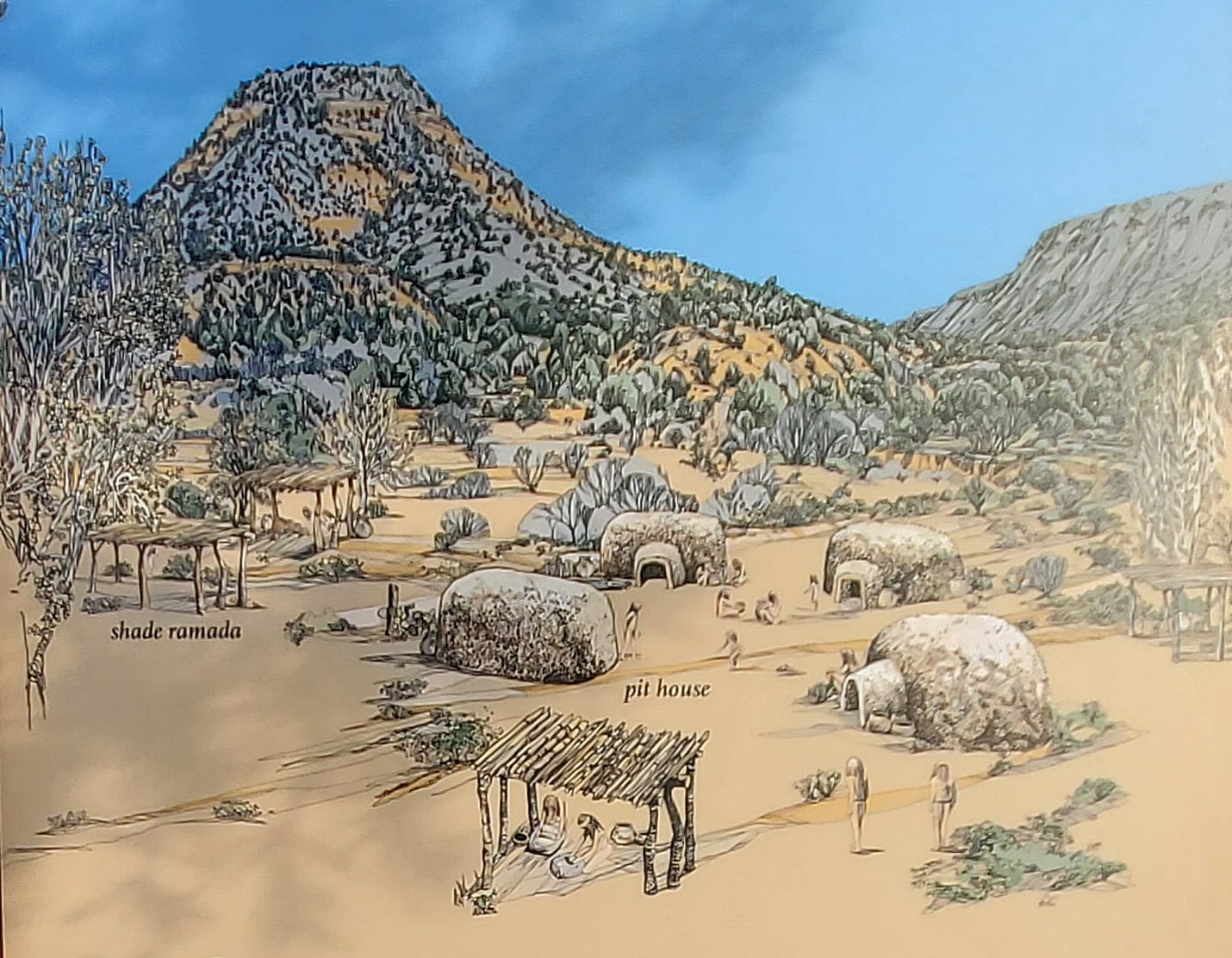
Sinagua Pit Houses
We did not see petroglyphs on our hikes. However, that doesn’t mean they aren’t there. Please be respectful of our past and don’t disrupt archeological sites and for goodness sake, please DON’T DRAW OVER THE EXISTING PETROGLYPS AND DON’T ADD YOUR OWN! Take only pictures and leave only footsteps.
Per the site Dream Sedona (Oak Creek): Sedona is famous for its uniquely beautiful landscape. Just mention its name and visions of red rock buttes, rising canyons, shimmering creeks and wilderness areas appear. Serene, tranquil and sacred. It is no wonder the ancient Sinagua Indians chose this area as home over a thousand years ago. They inhabited the Sedona and Flagstaff area until about 1400 when they mysteriously disappeared.
Evidence of their existence is littered everywhere. They stand stately as well-preserved Indian Ruins that are tucked on the surrounding cliffs, deep within canyons and along flowing waters. Some are secretly hidden only known to a few. There is no doubt others that have yet to be discovered at all.
Read more about the Sedona Area Indian Ruins.
The Sinagua lived as family units in pit houses. The yavapai refer to these people as “pahtyan” meaning “ancient ones.” They experimented with agriculture, but also relied on foraging. Eventually they expanded their agriculture to include corn, squash, beans, and cotton. About 88 years ago, they shifted to village life at structures built high in cliff walls, like Montezuma Castle, Honanki, and Palatki. The Sinagua left the Verde Valley around 1425.
Bands of Wipukapaya Yavapai were probably living in the Verde Valley before the Sinagua left. Dil zhe’e Apache moved in some time later. Both groups moved regularly to hunt game and gather plants to be used for food, clothing, baskets and medicine. They lived in temporary structures, called oways (or wickiups), constructed from a frame of ben branches covered with brush and grasses. Yavapai and Apache people continue to live in this part of Arizona.
Per Weather Spark: In Sedona, the summers are hot and mostly clear and the winters are cold and partly cloudy. Over the course of the year, the temperature typically varies from 35°F to 94°F and is rarely below 27°F or above 101°F.
Based on the tourism score, the best times of year to visit Sedona for warm-weather activities are from late May to early July and from late August to early October.
Dangerous Animals: This article from Only in Your State is quite informative – The 9 Most Dangerous Animals Found in Arizona:
This historic trail follows one of the first and most popular cattle trails out of the Sedona area. Upgrading of the trail began in 1896, but its completion as a wagon trail awaited the work of pioneer J.J. Thompson, funded by Coconino County, in 1902. It was known as the Munds Road and later as the Schnebly Hill Road.

Ocotillo (not a cactus) & Prickly Pear Cactus on Cathedral Loop Trail.
Per the U.S. Forest Service: What are those plants on desert hillsides that look like bunches of spiny crooked dead sticks? They are ocotillos (pronounced oh-koh-TEE-yohs), one of the most curious and unique plants of the southwestern United States. Despite their funny looks, ocotillos are common and adaptable desert plants. They grow throughout the Sonoran and Chihuahuan deserts from southeastern California to western Texas and south into Mexico. They grow at elevations from sea level to 6,700 feet, in a variety of soils, and associated with a variety of other plants.
From This is Tucson, 10 ocotillo facts:
Per National Geographic Encyclopedia: A mesa is a flat-topped mountain or hill. It is a wide, flat, elevated landform with steep sides. Mesa is a Spanish word that means table. Spanish explorers of the American southwest, where many mesas are found, used the word because the tops of mesas look like the tops of tables. Mesas are formed by erosion, when water washes smaller and softer types of rocks away from the top of a hill. The strong, durable rock that remains on top of a mesa is called caprock. A mesa is usually wider than it is tall.Mesas are usually found in dry regions where rock layers are horizontal. The Grand Mesa in the U.S. state of Colorado, considered the largest mesa in the world, has an area of about 1,300 square kilometers (500 square miles) and stretches for 64 kilometers (40 miles).
A good article on the history (and pre-history) of the area: Westerners Track the History of Soldiers Pass.
Per top-ten-travel-list.com: Seven Sacred Pools is a series of 7 natural pools which descend down the natural rocks. According to Red Rock Western Jeep Tours Operation Manager Randy Rohlf, these pools were considered sacred by the Apaches and Yavapai as the pools were considered a valuable source of drinking water year-round in a barren desert, and in addition, a sign of life and a means of attracting wildlife to the area.
Here is a good article by LiveScience.com on just what the heck cairns are. Rock cairns are human-made stacks, mounds or piles of rocks. They take different forms and have been built by cultures around the world for many different purposes. Cairns may serve as monuments, burial sites, navigational aids (by land or sea), or ceremonial grounds, among other uses. They may stand alone, in clusters, or in a network of related cairns; for example, as trail markers in a park.

Cairns - for the fun of it
For our purposes (at least for this website) cairns are small rock stacks that people (sometimes forest service and sometimes just regular hikers) make to mark the way. “The way” typically includes helping you navigate when the trail is not obvious, such as over rocks and rocky areas, and to mark a turnoff to a point of interest, like Soldier’s Cave.
Sometimes people build cairns for the fun of it, which can be confusing to hikers searching for the correct trail. Don’t do that in the wild. Also, parents, don’t let you children tear down cairns – just leave them alone. I met a man on the Fay Canyon Trail who was looking for the Fay Canyon Arch cutoff. I told him to look for a cairn to the side of the trail. He said that a parent had let their children push over all the cairns so that that cairn was probably no longer there. And, yep, when we passed the cutoff on our way back to the car, the cairn had been destroyed. I put it back up. Parents, teach you children to be non-destructive, please.
From the Orchard Canyon website: Before the red rock was turned into rock, it was all soft mud and sand. Over a 320 million year period changes in nature helped transform the sand and mud into something more beautiful than we could have imagined. Sea levels rose and fell during this time and with each rise and fall mud was added. During the sea level rise the mud would be washed in and then when it receded the wind brought in layers of sand. After years of this happening over and over again, the sediment was lithified (transformed) into hard rock.
The hard rock had a thin layer of iron oxide that was caused by chemical weathering of natural minerals. The process of the iron oxide weathering turned the rock its signature red color. At one point there was 1,900 feet of red rock covering Sedona. While we know how the red rock got there, how it was formed into beautiful natural sculptures is another story.
Oak Creek began to form and over time the other rivers in the area began to erode and break up the rock. The rivers would carry parts of the rock out to the ocean and leave behind red rock formations that we love today. When we look at the red rock formations we are actually looking at natural erosion taking place right before our eyes. Oak Creek, for example washes sand over the rock, smoothing it out like with a natural polishing type process. The sand also cuts a smooth groove through the rock that visitors float in during the hotter months of the year!
From the Visit Sedona website: Sedona vortexes (the proper grammatical form ‘vortices’ is rarely used) are thought to be swirling centers of energy that are conducive to healing, meditation and self-exploration. These are places where the earth seems especially alive with energy. Many people feel inspired, recharged or uplifted after visiting a vortex.
Although all of Sedona is considered to be a vortex, there are specific sites where the energy crackles most intensely. The four best known Sedona vortexes are found at Airport Mesa, Cathedral Rock, Bell Rock and Boynton Canyon—each radiating its own particular energy. Some are thought to produce energy flowing upward while at others the energy spirals downward, entering the earth.
Read more about Vortexes and where to find them here.
Our first night in Cottonwood. Had a beer, talked to a couple of locals and just relaxed. A nice place to get a beer and just hang out.
Wow! Probably the best (or at least most unique) place we ate. Again, this was our first night in Cottonwood after getting a tip from the guys at The State Bar. All vegetarian food. Live “band” – one guy playing the keyboard and singing, but he was very good. More food than we could eat so we had leftovers one night. Highly recommended and probably, the best place we ate the entire trip, although all the other places were good.
A big place on the corner. Many people, very popular. A good place to get food and drink. And the beer was very good.
As I said above, the Smelter Town Brewery & Main St. Café were great! You can take your pizza into the Brewery, as the brewery doesn’t have food. The brewery even has a menu for the café. And the folks from the café will deliver the pizza to you in the brewery. Very nice. The pizza was awesome, and the beer was also great. I am torn between this and Fojol Bro’s for best place eating experience of the trip. Do them both.
We stopped at the Merkin Vinyards tasking room in Old Town Cottonwood to…uh…taste wine. Honestly, we were not particularly impressed, nor were we unimpressed. It’s wine. The cool thing about Merkin Vinyards is that the vineyards are owned by the lead singer of Tool, Maynard James Keenan. I like tool! Many folks won’t, but I like weird rock-&-roll.
Following is a list of resources I have found most helpful for planning a trip to Sedona and the surrounding areas: